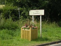

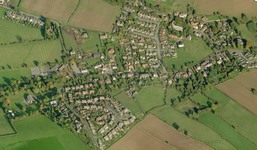
Here is a list of Land and Building Assets of the Council:-
Land Registered to The LPC
1) The Western half of the Lambley Playing Fields.
2) The Reed Pond Nature Reserve.
3) Lambley Parish Cemetery, Car Park and Drive.
Land Considered to Belong to LPC
1) Bus shelter and Gas hut up to 8 Main Street. Name “Bus Shelter”
2) Bank of beck at the corner of Orchard Rise. Used as a memorial site. Name “Memorial Bank”
3) Grass in front of Little Dumble (ex Peter Adams) with the old Telephone Box. Name “Telephone Box”
4) Grass on west of Church Street up to Gee’s. Name “Church Street Western Verge”
5) Land on east of Church Street given to us by the Church. Name “ Rectory Edge”.
6) The verge, roadside to the beck by the Church. Name “Church Verge”.
7) Orchard Rise/Woodlark green space. Name “Green Space”.
There are other small parcels of land around the village that are not registered according to the Land Registry map. These are likely to be in the ownership of the Nottinghamshire County Council (Highways).